

The Flight Path Anomalies of American 77
A classic case study of when things don't add up.

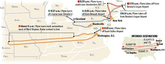
We all know the official flight path of American Airlines Flight 77, the plane said to have hit the Pentagon at 9:37 AM on September 11th, 2001. It shows the aircraft making a u-turn at the Ohio/Kentucky border and flying back east before finally looping around and disappearing into America’s famous military headquarters in Arlington, Virginia. Official sources such as the National Transportation Safety Board (NTSB) depict its flight path as described here:


The above illustrations are based on the NTSB's purportedly “meticulous” study of Flight 77’s flight path based on air traffic control recordings from 9/11 and the plane's Flight Data Recorder (FDR) information from one of its ‘black boxes’ reportedly retrieved from the Pentagon crash site.
Much has been made about the validity of the FDR data by 9/11 researchers such as Calum Douglas and Frank Legge, who provide their own conclusions about what it shows. Sadly, since to date no serial number has been provided for the FDR, there's no way to verify that it indeed belonged to American 77 (tail no. N644AA, serial no. 24602), even if it is legitimate. But that's for a future post I might do about Flight 77.
Even with versions illustrating the official flight path, though, there are discrepancies which to my knowledge has yet to be addressed by the authorities.
For starters, in some versions such as the NORAD flight path animation shown below, the plane is depicted making sharp turns during its spiraling descent (this was corroborated soon after the attacks by some air traffic control operators from Dulles International Airport, where AA77 last departed from, who are quoted below) and striking the southwest façade of the Pentagon from a northern approach with a sharp tilt to the right (confirmed by witnesses such as Gary Bauer and Albert Hemphill) or cartwheel motion:
“I was working the West Arrival and South Arrival positions combined. …. The target went a few miles south of DCA and then made a sharp turn northbound, back in the direction of DCA. ….” - William T. Howell, September 12th, 2001
“I observed a primary target approximately 7 miles east of AML, heading eastbound, …. When it was about 3 miles north of DAA it made a sharp turn northbound, when it was about 10 miles east of AML it made a sharp turn eastbound, ….” - Robert Utley, September 12th, 2001
“I looked out of my front window and I saw movement over to the side. I turned and looked and the plane came from behind us and banked to the right and went into the Pentagon.” - Gary Bauer, The Charlotte World, ca. 2001-02
“The aircraft, looking to be either a 757 or Airbus, seemed to come directly over the annex, as if it had been following Columbia Pike - an Arlington road leading to Pentagon.” - Albert Hemphill, September 12th, 2001
The north side approach is also corroborated by official depictions such as the NTSB animation of Flight 77’s journey to the Pentagon, which contradicts the south side approach the plane should've made to cause the physical damage observed around the military complex, such as the five downed light poles (it also contradicts the raw FDR data purportedly from AA77, which shows the final southern approach). As with NORAD's version, it depicts the plane flying near the Navy Annex before crashing into the Pentagon:
Then we have eyewitnesses such as Steve Chaconas, who told CIT that the plane actually flew from the east of and over the Potomac River, then turned around to the northeast and descended towards either Reagan National Airport (DCA) or the Pentagon, before finally leaving his line of sight in the area where he then saw black smoke emitted from seconds later, which he initially thought was coming from or near DCA until he later learned that it came from the Pentagon:
Next, we have press and witness reports from sources such as CBS News, Dulles ATC transcripts, and Scott Cook (who also wondered how he missed seeing the plane flying past him), which state that Flight 77 was seen flying near or over the White House and the Capitol building before turning back and crashing into the Pentagon. This would later be retracted by the press and authorities in the former's case, who then reportedly claimed that's not what was seen on radar (emphasis added):
“Top government officials have suggested that American Airlines Flight 77 was originally headed for the White House and possibly circled the Capitol building. CBS News Transportation Correspondent Bob Orr reports that's not what the recorded flight path shows.””
“At the White House Friday, spokesman Ari Fleischer saw it a different way.
“That is not the radar data that we have seen,” Fleischer said, adding, “The plane was headed toward the White House.”” - “Primary Target”, CBS News, Sept. 11th, 2001

“We didn’t know what kind of plane had hit the Pentagon, or where it had hit. Later, we were told that it was a 757 out of Dulles, which had come up the river in back of our building, turned sharply over the Capitol, ran past the White House and the Washington Monument, up the river to Rosslyn, then dropped to treetop level and ran down Washington Boulevard to the Pentagon. I cannot fathom why neither myself nor Ray, a former Air Force officer, missed a big 757, going 400 miles an hour, as it crossed in front of our window in its last 10 seconds of flight.” - Scott P. Cook, Cloth Monkey, 2001
Laura Bush would recount this fact years later in her 2010 memoir Spoken from the Heart, where she speaks of her experience in the PEOC bunker on page 204. The then-First Lady mentions that soon after her arrival in the White House bunker that Dick Cheney's wife, Lynne, would inform her quietly that “The plane that hit the Pentagon circled the White House first.” This news was apparently so distressing to the First Lady that she “felt a shiver vibrate down” her spine. She then says towards the latter half of the next paragraph that this incident occurred “a little past 9:30,” minutes before AA77 “crossed the river and thundered into the Pentagon.”


These accounts are corroborated by the NORAD communications from 9/11 (see page 35), where it's mentioned that the plane was seen flying “six miles East of the White House” on radar, which contradicts the official flight path and even Dulles ATC communications that show Flight 77 flying west of the White House and the Potomac River in the entire duration of its flight. It's up to you to decide which is more credible:


Reuters below depicted the plane hitting the wrong side of the Pentagon e-ring in one early illustration of the attack. Strangely, this graphic appears to support the account of Maria De La Cerda, who claimed shortly after 9/11 that she saw the aircraft “struck on the other side” of the building, which was not the southwest façade. Perhaps that's who this illustration was inspired by, since it was published around the time De La Cerda first gave her testimony to the Center of Military History (CMH) (ca. 2001-02):


And finally we have the RADES84 flight path radar coordinates for American 77, whose coordinates aren't completely congruent with the official loop we're all familiar with. Here's what I got below when I added the last 25 latitude/longitude coordinates into LatLongData:


You'll notice the above two screenshots depict the plane zig-zagging when it turned southeast near Alexandria, VA and during its last few seconds of flight prior to hitting the Pentagon further north of Alexandria in Arlington, VA. The final trajectory of AA77 (as depicted in the second screenshot above in orange) appears to be a botched amalgamation of the north and south side approaches, which, of course, contradicts the official straight southern approach the plane was supposed to have flown in the final few seconds preceding its crash into the Pentagon. Plus, it and the other above examples contradict the smooth circular turn Flight 77 was supposed to have made in the official loop, for they all display the plane making sharp turns in its last few minutes of flight.
And then you have versions of the entire official flight path where it’s only partially complete or differ from the NTSB version. Some illustrations don't even provide a flight path for American 77. These discrepancies will prove to be important later in this article, which has to do with apparent radar gaps in the region where Flight 77 was officially last seen. See for yourself:


To make matters worse, official sources can't even agree with each other on where the plane flew to after it disappeared at 8:56 AM. Some sources depict the plane flying further west to Kansas and Missouri from where it was last seen instead of turning back at the Ohio/Kentucky border to crash near Washington, DC, as documented by 9/11 researchers such as the 9/11 Omission Report and Mark Conlon, whose research I credit for inspiring this article. Even mainstream publications such as the Detroit News and the San Francisco Gate illustrates this version of AA77’s flight path, as shown below:


The San Francisco Gate's above illustration of American 77’s transponder being disconnected near Indiana (highlighted in dark grey) is also supported by Air Traffic Control communications from the day of the attacks, which mentions that the plane was last seen around southern Indiana before it lost radar contact (see page 53 of 161):

Then we have CNN's real-time Flight Explorer animation below (credits to Conlon), which was broadcasted a day after Flight 77’s disappearance and presumed crash into the Pentagon. It depicts the plane's green transponder signal having switched off when it flew straight into Kentucky instead of turning off over the border separating Ohio, Kentucky, and West Virginia as per the official story:
There's also another version below made by either the Federal Aviation Administration (FAA) or Flight Explorer which, again, shows Flight 77 flying all the way to the Midwest and hovering between Kansas and Missouri, which further corroborates what different mainstream sources such as CNN and the San Francisco Gate has documented:
These facts contradict the official flight path, which shows the plane disappearing over the Ohio/Kentucky border instead of further west of it, as illustrated by a later version seen below that was made by, you guessed it, Flight Explorer. Furthermore, it's evidence that Flight 77 did not really turn back to attack the Pentagon as reported.

Much of the above would later be corroborated by the release of government data such as the DCC (Dulles Control Center) radar coordinates for all four 9/11 flights, which were first disclosed between 2007-2014 in response to FOIAs requests made by researchers such as 9/11 Maps (Vincent Moreau) and John Farmer (via CIT/Pentacon).
The former mapped the DCC lat/long coordinates of American Airlines Flight 77 in March 2014, which once again shows the plane did not turn back over the Ohio/Kentucky border but instead flew past Kentucky and Ohio and into Missouri and Kansas, where it then flew back and forth and disappeared over eastern Kansas.

I confirmed this myself by mapping the Dulles Control Center radar coordinates for AA77 into LatLongData, which shows the same results. The last lat/long coordinates (38.233, -95.07; red ping 1) places the plane at 350 ALT (35,000 feet in the air) over Centerville, Kansas, which is 846 miles (flight distance) from Arlington, Virginia - where the Pentagon is located. The nearest airports to Centerville are Fort Scott Municipal Airport in Fort Scott, KS (50 miles) and Forbes Field in Topeka, KS (92 miles). Those airports could've been where Flight 77 landed, but that's open to further confirmation in the near future.


Some researchers such as Conlon have also suggested that AA77 might've landed at Lambert International Airport in St. Louis, Missouri, and there is even a photo from 9/11 of what appears to be an American Airlines Boeing 757 situated behind a fleet of TWA aircraft at that airport. See the picture below and judge for yourself:

While it’s possible it was Flight 77, I find it unlikely because the above evidence all suggests the plane disappeared in Kansas, and Centerville is 263 miles away in flight distance from St. Louis. Logically, one’d assume the plane would land at the airport nearest to where it was last seen on radar, especially during a national emergency as grave as the September 11th attacks.
Plus, it's not listed among the twelve American Airlines flights scheduled to arrive at Lambert that day in the BTS database. The only one that did land there was AA2426, which actually could have been the American Airlines plane seen in that photograph:

As a brief recap, Pilots for 9/11 Truth long ago published their research on the discrepancies with Flight 77, this time about its departure data. They revealed that the plane apparently flew from either Gates D21 or D19, rather than the official departure Gate D26, where some of the passengers were last photographed at. If their research rings true, it may lend credence to the involvement of duplicate flights in this operation:


The plane circling over the Midwest also supports the above animation in black and Barbara Olson's testimony to her husband Ted Olson that the flight was “circling around” after it was reportedly hijacked:
Some may argue that she was probably referring to the u-turn near Kentucky or even the loop into the Pentagon, but a u-turn is not really the same as “circling around” and the last “unknown” phone call Mrs. Olson reportedly made to her husband lasted from 9:30:56 AM to 9:35:16 AM (260 seconds), which ended just a minute after the plane began its circular descent towards the Pentagon. This meant that for much of the phone call, the plane didn't make any circular movements:


But in any case, it appears that that whoever was piloting American 77 by then was scouting over which airport in what state to land at, which might explain the back and forth motions observed in the DCC radar and the FAA/Flight Explorer versions. As I’ve shown above, it appears any airport near Centerville, Kansas was the final chosen destination for Flight 77.
Further evidence confirming AA77’s journey to the Midwest is found in documents such as the ATC, FAA, AEA, and 9/11 Commission (Miles Kara) transcripts, which all support the fact that American 77 was seen flying over Kansas and Missouri on radar when it was supposed to have turned back near the East Coast and crash into the Pentagon in Virginia.
Plus, they contradict the official narrative that the plane completely vanished from radar screens after turning off its transponder at around 8:56 AM before it supposedly reappeared flying eastbound in West Virginia at approximately 9:05-9:10 AM several minutes later.
They also go against the official timeline that stipulates the plane crashed at 9:37 AM, for the FAA, AEA, and 9/11 Commission files indicate the plane was still airborne well after that time, being visible on radar as late as 10:40 AM EDT (or 14:40 UTC), just over an hour after the Pentagon was attacked.


And even the 9/11 Commission itself essentially admitted in one of its early hearings that Flight 77 flew further west than the official narrative would now have you believe. This confirms everything else that's presented in this article, since West Virginia is not “way out in the West” of the United States but is near the East Coast. Debunkers will have a hard time explaining this admission away as a mere error on the part of the Commission in light of the corroborating evidence supporting it:

The damning evidence above might also explain why American Airlines Flight 77 was not seen on civilian and military radar screens turning around and flying back to crash near Washington, DC after 8:56 AM, despite claims that government agencies such as the FAA did track American 77 from the moment its transponder was turned off until the Pentagon attack, but that such data was not visible on radar screens during that time because it, perplexingly, was “not their practice to record primary radar” blips in the region where Flight 77 reportedly flew over on its way to the Pentagon (West Virginia).
They also explain why ATC operators initially searched the western United States for the plane instead of the east. If AA77 didn’t turn back but carried on west, that would explain why it apparently didn't reappear in West Virginia until almost 10 minutes after 8:56 AM, and why it was seen flying in the Midwest sometime later.
Even the 9/11 Commission investigative staff below expressed doubts about the peculiar disappearance and reappearance of American 77 in their email communications discussing the subject in 2004, a few years after the attack, where they ask how was it possible for the flight to have gone unnoticed by primary radar sites near the plane's eastbound trajectory and whether Flight 77 “did … ever actually enter ZDC airspace.” This was when it was already generally accepted as fact that AA77 did actually enter and crash within Washington airspace.


Furthermore, such eye-opening facts give credence to the possibility of duplicate flights involved, as stipulated in Operation Northwoods, which was first brought to light by the press in May 2001, a few months before 9/11.
The 9/11 Commission Report claims on page 25 that the reasons for Flight 77’s apparent complete disappearance from secondary and even primary radar screens for a total of “8 minutes and 13 seconds” (from 8:56 AM to 9:05 AM) were “technical, arising from the way the software processed radar information, as well as from poor primary radar coverage where American 77 was flying.”

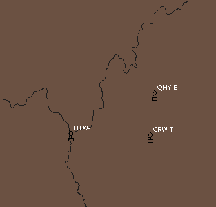
This is challenged by researchers such as Tom Lusch and the 9/11 Omission Report, who both show that the plane could've still been tracked by nearby radar centers following the eastbound return path it purportedly flew on 9/11. Even the 9/11 Commission Report makes light of the plane being still tracked by the FAA via its primary radar system after 8:56 AM, which contradicts what's said elsewhere in the report. And here below are the radar sites (discovered via Omission Report, edited by me) neighboring where AA77 was supposed to have turned back after 8:56 AM:

Air Traffic Control (ATC) radar sites could detect airborne ‘targets’ as far as 250 nautical miles horizontally and 60,000 feet vertically in 2001, and American 77 was 35,000 feet in altitude when it was over the Ohio/Kentucky border at 8:56 in the morning, so there was a slim chance the plane could've suddenly lost all radar contact from then on, unless it crashed or descended below a certain altitude, and there's no evidence to my knowledge suggesting that it did either before 9:00 AM.
The only way Flight 77 could suffer such problems was if it either descended to a low altitude (which is unlikely) or there was electronic jamming with the plane. Since there are so many inexplicable anomalies with this flight that I've documented here, the latter seems to be the more likely scenario, at least in my view. Electronic jamming could also explain why ATC operators working on AA77, such as Chuck Thomas, couldn't locate the plane even when they switched on primary radar to find it, despite it being allegedly tracked flying back east by the FAA. Plus, it would explain why American 77 was flying sharply back and forth between Missouri and Kansas towards the end of its flight.
It was probably no coincidence why a specialist in electronic warfare (Stanley Hall) is listed among the passengers of Flight 77. Such an individual would be handy in a ‘black operation’ like the 9/11 attacks, which was probably more akin to the infamous “Lone Gunmen” episode predicting the attacks (bar plane crash) than a bunch of subpar, scrawny terrorists violently hijacking and crashing the plane. You can bet Hani Hanjour and al-Qaeda were certainly not responsible for what we see here.
These anomalies also pose a problem for the official narrative of American 77’s hijacking. If the plane at some point was really taken over and commandeered by suicidal hijackers with intention to crash it into some important building or monument around the East Coast, why would they fly the plane so far away from their desired target? Unless they actually wanted to crash or land Flight 77 somewhere in the Midwest (e.g., ram it into the Missouri State Capitol in Jefferson City, MO, where it flew past, by the way), what reason did they have to fly it very far away from DC? Even within the official narrative, it made little sense for the hijackers to wait half an hour before finally taking action, since that meant the plane was hundreds of miles away from the Pentagon or any federal building within the vicinity of the Nation's Capitol. Being far away also increased the chances of interception by the authorities or the plane's captives timely retaking control, since both groups had more time to respond (as was apparently the case with United Airlines Flight 93). Not to mention, plenty of jet fuel was wasted in the process, which reduced the fire damage crashing the plane would have caused and thus ran contrary to the purported objective of the terrorists to hijack and crash a cross-country flight that carried tons of kerosene for the long journey. Seems pretty counterintuitive to me.
But if whoever was really behind the attacks were going to do a switch with another identical aircraft (per Northwoods), it made perfect sense to fly it far away from populous areas like Washington and swap it in midair with a similar plane over a rural area with “poor” radar coverage such as the Ohio/Kentucky border. Doing so would decrease detection from those monitoring the plane who aren't part of the plot. Plus, it could be covered up with rumors of a crash in the area where the aircraft was last visible, which is exactly what happened with Flight 77:
(Speaking of the passengers, Leslie Whittington, who also reportedly flew on AA77, was a native of Kansas. So it's fitting that her plane was seen hovering over that state shortly before it disappeared and well after it supposedly crashed hundreds of miles east of Kansas in Virginia.)
(Also envisioned in the Northwoods doctrine was swapping a chartered flight that flew “a group of college students off on a holiday” with a replica drone that will be downed in its place (page 10). Flight 77 reportedly had a group of students and teachers onboard that were on a trip to California which was sponsored by NatGeo, and even that has been put into question by what I've discovered about AA77 previously. But in any case, what are the odds this is not yet another detail inspired by Northwoods that was slightly repackaged, especially in light of all the oddities with the plane I've highlighted here?)

If any of my readers have relevant insightful info I could use for my Flight 77 research (which I haven't seen before), please let me know. If you want me to credit you for the finds, I'll do that, too.
I give thanks to Mark Conlon and 9/11 Omission Report for inspiring me to write this article with the help of their stellar research into this subject. I wouldn't know what to do without them.
The Missouri State capital is in Jefferson City. Not st. Louis.